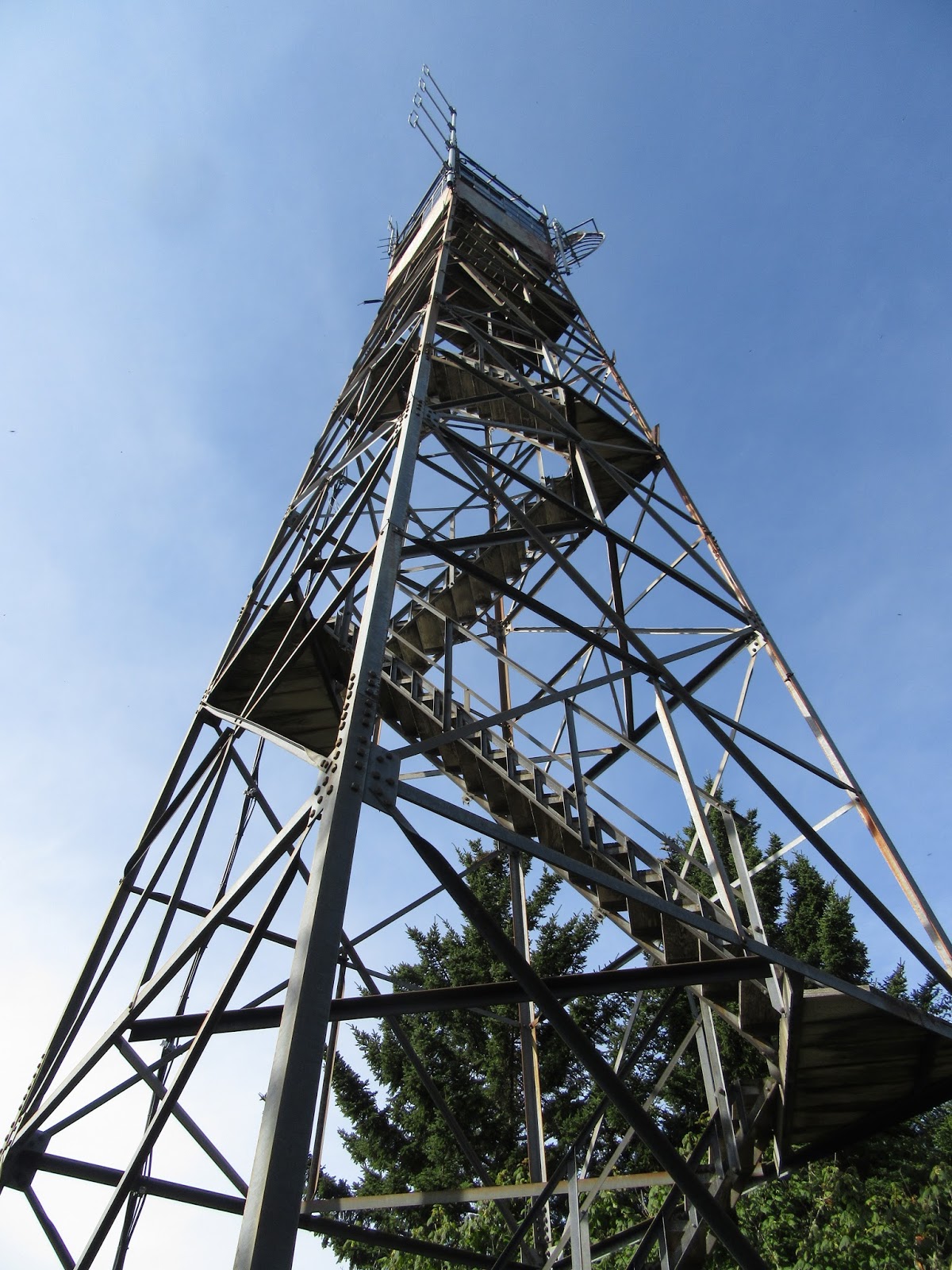
Rich Mountain Trail

Hike #47 : September 7, 2015


5 miles
2.3 new miles
584.3 total overall miles
389.2 total miles of 800.8


The Rich Mountain Trailhead is a short walk from the Ace Gap parking area at the northern border of the park. Much like the Indian Grave Gap Trail, Rich Mountain is a steady climb along an old roadbed.


Rich Mountain Trail

The trail is a moderate climb for the first mile or so before becoming more streneous as the climb up get more serious. There are several glimpses through the trees that reveal some marvelous views.


Views from Rich Mountain

Views from Rich Mountain

One can't help but think that were it not for the trees, this trail could have some of the best views in the park. I may have to come back in the winter months and give it another go after the leaves are down.

After the uphill climb, I finally come to campsite #5 where I'm eager to shed the backpack and have lunch. You can still see the few remains of the old shelter that used to stand here.

Having already hiked Indian Grave Gap up to Rich Mountain Loop earlier, this second trip up has wore me out! Just a tenth of a mile past the campsite is the junction with Indian Grave Gap and the turn around point for the hike.


TRAIL REVIEW

Rich Mountain Trail - 2.3 miles (one way)

Campsite #5


Wanna hike the 900 without getting lost? Start by checking out the book Day Hiker's Guide To All The Trails In The Smoky Mountains by Elizabeth L. Etnier.

Hiking Trails of the Smokies or "The Little Brown Book" from the GSMA


There is loads of information in the pages of GoSmokies.com.

Indian Grave Gap

Hike #47 : September 7, 2015


2.4 miles
1.1 new miles
579.3 total overall miles
388.3 total miles of 800.8


Labor Day. What a fine day for a hike (like every day!).

The original plan was to hike Hannah Mountain but as I arrived to a closed Parsons Branch Road, those plans were quickly thwarted. I still have no idea why the road was closed but I certainly had no desire to hike the extra three or four miles along the road just to reach the trailhead. I did go ahead and walk up to the Boring Family Cemetery since I was there. Its a beautiful small cemetery just past the gate to the right at the top of a access road. My hopes of ranger coming by and opening the gate were never realized so it was time for plan B.

As I pulled off of Forge Creek Road back onto the Cades Cove Loop, I was still trying to figure out just what plan B might be. I stopped by the Cable Cemetery. I stopped by the Cades Cove Nature Trail. Then, on a whim, I decided to just go knock out a few short trails off of Rich Mountain Road. So, I circled back around the loop and finally made it up the one way gravel road to the Indian Grave Gap Trailhead where, at 9:30, I finally got to do some real hiking.


Indian Grave Gap Trailhead at Rich Mountain Road

According to the map, this is a one way 1.1 mile hike. It feels good to get going as the trail winds up. It starts as a wooded and secluded moderate hike along an obvious old roadbed. Considering that its likely not a very used trail, I find it in surprisingly good shape. About half way up, the views down towards the Cove are spectacular. That's always especially nice when its unexpected.


Looking down into Cades Cove
 Although the trees do a good job blocking many potential views, there's several glimpses along the way.


Incredible view from Indian Grave Gap

Just after these pictures were taken, I come around a bend in the trail and that's when I saw the deer. It was a big buck, 8 to 10 pointer. He was standing there with that... well, that deer in the headlights look. I get my camera for what I imagine will be a great pic when he makes it clear who is going to be the boss here. He starts walking agressively towards me. Never once slowing or looking away.

Now, as a hiker, I've been schooled time and time again about what to do when encountering a bear on the trail. But a deer? Not so much. I not gonna lie, I was a little concerned (re: scared). I mean, here I am on a secluded trail, all alone. Since I'd planned on hiking Hannah Mountain, no one even knew where I really was. If this buck tears into me... it could be bad. Really bad.

First, he sizes me up...

 and here he comes...

 getting a little too close...

As you can see in the above picture, a doe came down the ridge behind the buck. Guess he was trying to impress his lady.


When she appeared, he stopped and turned to her. Thankfully!


As the doe ran down the ridge, he took a quick bite and follwed after her.


The last couple of pictures are a blurry mess but what can I say? That's what happens during near death killer deer encounters.

and there he goes...

  
The remaining half mile up is steep. Really steep. Thanks to that buck, my adrenulin is going strong and helps me make the climb.


Near the top of Indian Grave Gap

Just thought this was a beautiful sight

Upon reaching the junction with the Rich Mountain Loop Trail, its time to retreat back to the trailhead. Indian Grave Gap actually continues as part of the loop for another 2.6 miles all the way to the junction with Scott Mountain and Crooked Arm Ridge Trails but I've already hiked that a few times so its on the next trail...


TRAIL REVIEW

Indian Grave Gap Trail - 1.1 miles (one way)


Wanna hike the 900 without getting lost? Start by checking out the book Day Hiker's Guide To All The Trails In The Smoky Mountains by Elizabeth L. Etnier.

Hiking Trails of the Smokies or "The Little Brown Book" from the GSMA


There is loads of information in the pages of GoSmokies.com.

Mt. Sterling Trail

Hike #46 : August 29, 2015


14.4 miles
2.7 new miles
576.9 total overall miles
387.2 total miles of 800.8


The Mt. Sterling Trail has been on the old hiking radar for a long time. So when Randy was ready for his first fire tower experience, it was time to go!


Mt. Sterling Fire Tower

Eddie, Randy and myself decided to make the hike into a car drop so that we could hike up to the tower and and down Big Creek stopping by Mouse Creek Falls and the Midnight Hole. So after leaving a car at the Big Creek Trailhead, we made our way along the seven miles of graveled Mt. Sterling Road (which turns into Old Cataloochee Turnpike after a while) to the trailhead on the right.

After reaching the trailhead, the hike begins as a moderate climb. Before we can even get into a groove, I suddenly hear the bloodcurdling horrific sound of Randy yelling "BEAR!!!!!!!!!!!!!!" to the top of his lungs. Before I could even get turned around, the mama bear had flew down a tree like a firefighter on fireman's pole, no doubt scared half to death by Randy's banshee scream. The rather large cub, however, lingered behind most likely too scared to know what to do. Eddie and I snapped a few pictures while Randy inched forward on the trail. I'm pretty sure that was his way of saying 'let's get the hell outta here before we die a bloody horrific death by bear mauling!' Lol! So, we moved on after the cub finally scurried down the tree and off towards its mommy. Pretty cool way to start the day!


As Randy would say... its a BEAR!!!!!!!!!!!!!!!!

Soon after the not-so-deadly-after-all bear encounter, we come to the trail junction with the Long Bunk Trail to the left. This is the only real level part of the trail. I've heard that Mt. Sterling Trail is one of the hardest in the park and the next mile and a half definitely test one's hiking abilities. It's straight up.

 I was surprised by all the blooming flowers along the way.


After a mile and a half or so, there's a wonderful view to the left of the trail where the power lines cut through the forest.


The view from the Mt. Sterling Trail

From here, the trail continues up hill but at a much more moderate rate and before we know it, we've reached the end of the Mt. Sterling Trail as we come to the Baxter Creek Trail. That first mile and a half was rough but I wouldn't call this the hardest trail in the park. Not at all. A right turn onto Baxter will lead to the fire tower just past campsite #38.

The tower rises 60ft. and allows unrestricted 360° views as far as the eyes can see.


First view of the tower

What a view!

Campsite #38 in the shadow of the tower

Now, as I've said before, I do not like nor do I handle heights particularly well. And by not particularly well, I mean they scare the bejeezus right out of me. My fear of heights, however, may pale in comparison to Randy's. It's kinda nice not being the least experienced hiker after all these hikes with Eddie the superhiker. Surely after already climbing this tower and the similar tower at Shuckstack, I'd be just fine and show Randy how it's done. Yeah... not so much. For some strange reason the first two flights of stairs are terrorizing! Forcing myself on, it gets easier the further up I go. Still, when I climb into the top, I'm shaking like a leaf in a hurricane. It was several minutes before I could gather myself enough to take pictures.

As I was hollering down words of encouragement to Randy, thinking he wasn't going to make it, when he suddenly appeared at the door! He'd defied logic and made the climb! He didn't hang around long but he made it! Even Eddie, after a little peer pressure, made the climb.


In the tower...

Look who made it!

Several minutes and dozens of pics later we climb down, had a snack and moved on back down Baxter Creek Trail to the junction with Swallow Fork and Pretty Hollow Gap. From here we head down Swallow Fork to Big Creek which I've previously blogged about here a few years ago.

I will mention that since I was pretty badly injured the last time I hiked down Big Creek, I passed up the opportunity to stop by Mouse Creek Falls and the Midnight Hole even though they are both just off the trail. Not this time.


Mouse Creek Falls

Midnight Hole

A nice double waterfall just past the Midnight Hole

We had an absolute wonderful time on this hike. Sometimes there just isn't anything better than being out on the trail with good friends. Aside from the steep beginning and the distance covered, it was a mostly not too bad a hike (I refuse to call any trail easy) with almost all of it downhill after the fire tower.

Miles covered and fears conquered (at least until the next time!)


Happy trails!


TRAIL REVIEW

Mt. Sterling Trail - 1.8 miles

Baxter Creek Trail - 2 miles

Swallow Fork Trail - 4.0 miles

Big Creek Trail - 5.1 miles


Campsite #38

Mt. Sterling fire tower

Mouse Creek Falls

Midnight Hole


Wanna hike the 900 without getting lost? Start by checking out the book Day Hiker's Guide To All The Trails In The Smoky Mountains by Elizabeth L. Etnier.

Hiking Trails of the Smokies or "The Little Brown Book" from the GSMA


There is loads of information in the pages of GoSmokies.com.

A Little Porters Creek and a Whole Lot of Fun

Hike #45 : August 23, 2015


10.2 miles
1.8 new miles
562.5 total overall miles
384.5 total miles of 800.8


I don't know why in the world it has taken me so long to hike on Porters Creek Trail but I'm glad it did. Why? Because if you're going hiking in Greenbrier, nobody knows it better than my friend and guide, Mike Maples. Although its not really off trail season, one little adventure wouldn't hurt. So let's go!

Randy and I met Mike at the ranger's station in the Brier at 8am and headed on down the gravel road as Mike gave us a history lesson along the way. Mike has an incredible knowledge of the places and people that made up this once thriving community. His love and passion for this area is abundantly clear in every word of every story he shares. I only wish I could retain a small portion of his knowledge.

The first mile of the trail is a wide gravel road bed that follows alongside of the creek. About .7 of a mile in, we cross Long Branch (see, Mike, I finally remembered the name!) by way of a footbridge and come to the rock stairs and a zig-zagging rock wall to the right side of the trail. This was home to Joel Ownby and later to Vanderbill Whaley before the creation of the park*.

*Edited from an earlier post where I confused this with the Cantrell place. Thanks for keeping me honest, Mr. Maples! Lol!


Steps leading to the old Joel Ownby place

Just a short ways from the Ownby place, a side trail to the right leads to the Ownby Cemetery. Although I'd been here a few years ago, I was glad to be back. My love and appreciation for these beautiful fading cemeteries has grown immensely and I feel somehow connected with them now.


Ownby Cemetery

Just a ways beyond the cemetery there lies the old remains of a truck just off the trail. I'm sure this is missed by most but is clearly visible once you know its there.


Rusting away

After a mile, the road ends at what is called Porters Flat. From here the trail goes on to the left but we head to the right toward the Brushy Mountain Trail to the John Messer farm site. Here we see the beautiful cantilevered barn along with the hiker's cabin built by the Smoky Mountain Hiker's Club in the 30s. There's also a two person outhouse on back beyond the cabin.


John Messer Barn

Spring House

Hiker's Cabin

Now, when hiking with Mike, he sometimes shares some (never all, I suspect) of his secrets and hidden places. These belong to Mike and I'm not giving them away. I guess that's the main reason I've never blogged about our hikes together. That and the fact I seldom even know enough about where I'm at in the first place! Anyway, after leaving the Messer place we head off trail. Mike leads us right to several cool spots including the nearly reclaimed foundation of another cantilevered barn.


Barn remains

As Mike was sharing the history of this barn with us, a deer walked right up to us. She seemed fascinated by us as if she'd never seen a human before. She stayed within sight for quite a while. Sometimes the mountains are like your own private Disney movie.

After a while just meandering around in the woods, we connect with the Brushy Mountain Trail and head back to Porters Creek. Along with a little light rain, we reach Fern Branch Falls. There wasn't a lot of water flowing but that didn't take away the beauty of it. I made the slippery walk up to the falls while Randy and Mike took a snack break.


Fern Branch Falls

Just a little cold water trickling down...

From the falls, we head back down Porters to the car where we head off to the next adventure of the day... the Barnes place.

The remainder of this hike is all off trail. As Mike always says, "Hike off trail at your own risk!"

Again, its not my place to reveal exact locations and such but there are several blogs about the Barnes site including one from Mike himself on his GoSmokies blog.

After reaching the trailhead, which is not marked or particularly well visible, we begin the climb up. The climb is around two miles up and I mean UP. Unrelentingly up. Going off trail around Porters Creek was relatively easy but this climb is more what I'm used to with a Mike hike. Mike is also a hiking machine and he can be hard to keep up with but Randy and I do our best. As we reach the last little bit of the climb, things become rather overgrown and the briers are thick but we scratch our way through and find the three small tombstones of the Barnes children waiting at the top.


The Barnes children cemetery

I've seen this small cemetery referred to as the saddest place in the entire park. Maybe it is, maybe its not... but it does evoke emotion. The thought of a family losing a child on Christmas Day is horrible in itself but to then have another child born exactly one year later, again on Christmas Day, like some Christmas Miracle only to lose it... Well, I can't even imagine.

A little further past the graves, Mike showed us the remains of the Barnes cabin. All that's left is a portion of the stone chimney.
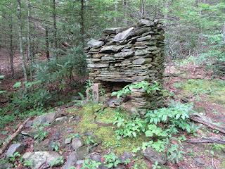

John Barnes' place

The hike back down was much easier than the climb up but still steep. And that's where the trip comes to a close. I love hiking the park's trails and I hope that someday I will be blessed enough to walk each and every one of them. Still, I have found there's so much more out there than what's on any map. You just have to know where to look or who to walk behind.


Until next time, keep it in the dirt and happy trails!


TRAIL REVIEW

Porters Creek Trail - 1.8 miles

Brushy Mountain Trail

Off trail - somewhere around 8 miles, give or take.


Messer Barn, Hiker's cabin, spring house, etc.

John Barnes Home site

Barnes children graves

Other old homesteads, barns... and just a bunch of cool stuff


Do yourself a big favor and check out Mike Maples on GoSmokies.com! You might learn something!

Wanna hike the 900 without getting lost? Start by checking out the book Day Hiker's Guide To All The Trails In The Smoky Mountains by Elizabeth L. Etnier.

Hiking Trails of the Smokies or "The Little Brown Book" from the GSMA


There is loads of information in the pages of GoSmokies.com.

Appalachian Trail: Clingmans Dome to Newfound Gap

Hike #44 : August 15, 2015


8.4 miles
8.2 new miles
552.3 total overall miles
382.7 total miles of 800.8


For this hike, I'm joined by Eddie and Randy (who was fashionably late, I may add) at Newfound Gap where we drop a car and head for the highest point of the entire Appalachian Trail, Clingmans Dome.


Newfound Gap

From the parking lot at Clingmans Dome, we head up towards the observation tower. Its a nice cool morning with fantastic views as we walk the paved road up. This little walk, although a short half mile, is always surprisingly rough. Its no wonder there are several resting spots along the way. I imagine many a tourist cuss that walk.

We, of course, stop by the tower and soak in the views which were much better than I thought they'd be. Its always hit or miss at such a high elevation.


Clingmans Dome

From the tower we connect with the Appalachian Trail heading towards Mt. Collins. The trail is a lush explosion of mossy green.


The Appalachian Trail

The trail is absolutely beautiful. The surface of the trail is rocky with many steps along the way as we make our way downhill. You would tend to think that walking from the highest point of the AT to anywhere would be all downhill. You'd be wrong. This is the Smoky Mountains and the rule of thumb is: Its always uphill! At about 2 miles down, we reach Collins Gap and begin the climb to Mt. Collins. For the next mile the trail is rather steep and strenuous before leveling back out in time to arrive at the junction with Sugarland Mountain Trail. Just past Sugarland Mountain on the left, we come the Fork Ridge Trail junction exiting to the right. Its just a short walk along Fork Ridge Trail to Clingmans Dome Road, so we walk out and back to go ahead and collect that small section of trail.

The trail rolls up and down for the next 2.5 miles through more mossy beauty. This part of the trail is very unique with many uprooted trees. The enormous roots, exposed, are awe inspiring.


Eddie standing beneath a huge exposed root holding a large boulder. 

These roots stand easily 15 foot or higher as I stand 6'2" in front of them.

The trail continues mostly downhill until coming to the junction with Road Prong Trail. Here the trail briefly emerges from the forest meeting with Clingmans Dome Road before continuing on back into the woods. Here we begin to get a little rain and I soon meet with my second bee sting of the summer. This time a honey bee somehow found his way beneath the tongue of my shoe where he gave his life just to sting little ol' me. Honey bee or no, it still freaking hurt! Time to hike the pain away. I pour it on and double time it up the next half mile until reaching the Beech Forest Exclosure where the trail actually goes over the fence, twice.


Platform to walk over the fence at the Beech Forest Exclosure.
From here, its pretty much downhill and we keep our eyes peeled for the famous and yet somewhat hidden "Hiker's Tunnel". There are several 'trails' that walk to the road along this stretch. Although Eddie had convinced Randy and myself he was 99.9% sure he knew where the tunnel was, my confidence was waning. Oh, who am I kidding? I thought he was full of crap and that we'd most likely missed it. Just then we came to a steep and rocky water drain and Eddie attempted a joke by saying that it was the trail to the tunnel. When I turned to look, I saw what could possibly indeed be the tunnel. What a coincidence, eh? I nominated myself to scout it out and sure enough, we'd found it. If not for Eddie's smart aleck little joke, we'd probably missed it.


The Hiker's Tunnel!
View from Clingmans Dome Road directly above the Hiker's Tunnel.

From here, the hike is all but over and we are soon back in the Newfound Gap parking lot. This is a very impressive hike and certainly one worthy of doing again someday. Just another reminder of how blessed we are to live so close to not only the Smoky Mountains but also the Appalachian Trail that dissects it. Great hike!


TRAIL REVIEW

Appalachian Trail - 7.7 miles

Clingmans Dome Overlook

The "Hiker's Tunnel"


Wanna hike the 900 without getting lost? Start by checking out the book Day Hiker's Guide To All The Trails In The Smoky Mountains by Elizabeth L. Etnier.

Hiking Trails of the Smokies or "The Little Brown Book" from the GSMA


There is loads of information in the pages of GoSmokies.com.