Hike #40 : July 11, 2015
13 miles
12.5 new miles
507.3 total overall miles
360.2 total miles of 800.8507.3 total overall miles
For this hike, Randy and I leave Eddie behind and do our own car drop hike starting at the Laurel Falls Trailhead parking lot and ending behind the Sugarlands Visitor Center at the park headquarters.
Our early start was met with some heavy rains on our way from Knoxville but we were optimistic that the rain and clouds were moving on through. We left my truck at the trailhead of Cove Mountain next to the park headquarters on Sugarlands Residence Road and drove to the Laurel Falls Trailhead just off Fighting Creek Road where we were surprised to be the first ones there. Laurel Falls is likely the most used trail in the park up to the point of the actual water fall and thus the parking lot fills fast.
Laurel Falls Trail begins as a paved trail. Its very evident that this trail is overused and not respected by many of the tourist that have left their marks with either useless side trails eroding the land or graffiti scratched into the rocks along the way. Its sad to see this misuse. Around a half mile or so up, as we stopped to take a few pictures of some of the many excellent views , we heard the sound of heavy rain heading our way. Quickly. It hits us before we had a chance. A short run ahead, we slip slightly under a rock overhang enough to get on our rain gear and continue on. I traded out my rain jacket for a poncho. Very pleased with the results and I'll be a poncho man from here on out.
 |
| Smoky view from Laurel Falls Trail |
 |
| Laurel Falls. |
Continuing on past the falls, its immediately clear that 99% of the people hiking this trail turn back at the falls. The trail is no longer paved and returns to good old rock and dirt. The trail is basically an all uphill walk but we found it to be not too difficult and surprisingly beautiful.
At 3.1 miles, we came to the trail junction with the Little Greenbrier Trail to the left. From here, the trail begins what I would call the hardest incline of the hike. At only .9 of a mile, it doesn't last too long though and we soon come to the junction with Cove Mountain Trail. Cove Mountain heads to the right but first we went left to check out the fire tower which is marked on the trail sign.
 |
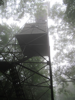
| The Cove Mountain Fire Tower hiding in the mist atop Cove Mountain. |
The tower stands at 60 feet tall and is much the same as the ones on Shuckstack and Mount Sterling except hikers are not permitted up past the first level of steps. This tower has been converted by the park to monitor the air quality. Its still definitely worth the short walk to see it when you're here. After some pics, we head back to the junction and on our way down the mountain.
 |
| The Cove Mountain Fire Tower |
Cove Mountain Trail may be the only trail I've been on in the Smokies that is, at least for several miles, covered in grass. Its obviously not faced with heavy traffic at all. My kind of trail. The trail runs along the park boundary for about 6 of its 8.4 miles and then along Newfound Gap Road until returning to the parking lot at the park headquarters. I loved this trail. Its quiet and secluded despite its location and offers so much beauty and diversity along the way.
 |
| The beautiful Cove Mountain Trail |
Its a mostly downhill hike with a few good sized hills to keep your heart pumping. After 8.3 miles on the Cove Mountain Train, we come to the first people we'd seen since Laurel Falls as we reached Cataract Falls.
 |
| Cataract Falls |
Again, since this waterfall is only .1 of a mile from the parking lot, it is very popular and overused. Even more so than Laurel Falls as people have climbed all around it causing some serious erosion problems along with trash left behind. Still, it is a beautiful albeit somewhat small waterfall.
Randy and I wrapped things up by visiting the Old Evans Chapel Cemetery that is connected to the parking lot.
 |
| Old Evans Chapel Cemetery |
All in all, it was another amazing day in the park. It just never disappoints!
Happy hiking!
TRAIL REVIEW
Laurel Falls Trail - 4 miles
Cove Mountain Trail - 8.4 miles
Cove Mountain Fire Tower
Laurel Falls
Cataract Falls
Wanna hike the 900 without getting lost? Start by checking out the book Day Hiker's Guide To All The Trails In The Smoky Mountains by Elizabeth L. Etnier.
Hiking Trails of the Smokies or "The Little Brown Book" from the GSMA
Hiking Trails of The Great Smoky Mountains by Ken Wise
There is loads of information in the pages of GoSmokies.com.
No comments:
Post a Comment