Mike Hike #5: The Greenbrier Pinnacle and Cat Stairs

September 26, 2015


11 or so miles
Mike Hike miles are not part of my journey to the 900. 
They're just good for the soul.


Off-Trail Hiking with Mike Maples


View from thr Cat Stairs

I met Mike and new hiking friend Joe Ferrell in Greenbrier around 8am and the adventure soon began. We start off walking along the old roadbed headed towards Ramseys Cascades. Its a nice walk that gives Joe and I time to get acquainted while Mike schools us on our surroundings. After about a mile and a half the roadbed ends at a turn around where the trail to Ramseys continues and a unmarked trail switches back off to the left.


Mike standing at the Greenbrier Pinnacle Trailhead

That unmarked trail is where we're headed. The trail begins as a well-defined path. Although its a steady uphill walk, its not particularly steep. As we continue, there are many downed trees (some very large) that we have to either climb over, go around or even crawl under. Although this is an old jeep road, its hard to imagine that today as time has eroded much and the forest reclaimed most of it. There's a few spots that become ugly and difficult with several slaps to the face by encroaching vegetation of all sorts. Joe was particularly fond of the brier patches!


Joe fought the briers and the briers won!

As I remember, and since my GPS was malfunctioning (!), it was about a mile and half from the junction when we came to a few extremely large trees. One directly to the right touching the trail and another a few tenths of a mile further up, also to the right of the trail about 10 or 20 feet. There are many rhododendron tunnels along the way, and you know how much I love rhodo-tunnels!


Mike and the beanstalk... uh, I mean big tree!

At 3.1 miles from Ramsey Prong Roadbed, we made it to the overlook to the left. Absolutely amazing!

View from the Pinnacle Overlook

After a much need lunch break and some good conversation, we take bunches of pictures and decide to head on up to the top where the old fire tower used to be. At this point we're just kinda playing it by ear as to what the ultimate destination might be due to the fact that we're all old and the weather could take a turn. But the weather is fine as we head up the next .4 of mile. The trail to the top is directly behind you as you look out at the overlook and is also mostly well defined, however it is a steep climb and quite difficult to maneuver as it is seriously overgrown. More face smacking and brier snagging!


This steel post marks the end of the steep climb up to the ruins of the cabin and fire tower.

At the top, we find where the old cabin once stood directly in front of the fire tower ruins. Mike posted a great video about it. Notice the Hollywood style camera work?


The cabin well

Fire tower ruins

From here, we return the way we came and Mike stops at a faint side trail that leads the way to the Cat Stairs. The three of us decide we're ready for more, so Cat Stairs, here we come!


Cat Stairs Trail

The "trail" is very faint to nonexistent almost immediately. This is for all intents and purposes bushwhacking. A few very steep drops, some crawling and climbing and a few glimpses of beauty above the forest growth are keeping us alert.


Cat Stairs Trail. Trail? We don't need no sticking trail!

Upon reaching the "stairs", the word steep takes on an entirely new definition. Mike suggest we scoot down the dirt on our butts and leads the way. I try to maintain on foot with success, albeit frightening success, while Joe goes full on dirt slide behind me. Joe took a few unplanned scoots here and there and earned himself a new trail name: Scooter. We came to a protruding rock after, I may be wrong here but I think it was after this first major downhill slide, where the view rivals any that I've seen in the park. Stunningly amazing.


View from the Cat Stairs

Another view from the Cat Stairs

Soon we're to the next couple of super, incredibly steep drop-offs. More amazing views along the way.


Scooter earning his trail name!

Mike goes scooting down, down, down!

Cat Stairs

Views!

Amazing views!

After we finally made it safely through the Cat Stairs we start doing some sideways walking through the super steep forest.


The Greenbrier Pinnacle. We just came down the left side!

The trail disappears a time or two so Mike just wanders here and there until it reappears like magic. I made it all the way through the Cat Stairs and all the ridiculous steepness only to trip over God knows what and take a little fall to my knees as we made our way to a well worn trail. This trail leads to familiar territory. A nice walk leads to the Barnes place where Randy and I walked with Mike about a month ago (link: Mike Hike #4).


Barnes Place

Barnes Children Graves

From here we hike on out with one little Mike Maples shortcut along the way. A nice area just over a long rock wall that he referred to as an old CCC dump site. A cool way to end one of my most favorite days in the park. 


Old CCC truck

Forgotten bridge supports

As much as love the trails in the Smokies, there's something magical about going where few will ever tread. Having the extraordinary opportunity to join Mike for these adventures is a blessing. So, in summary, the weather turned out perfect and no one got (seriously) hurt and the hike was absolutely amazing. Easily, one of the best ever! I call that a great day!


Thanks, Mike!


Want to learn more about Mike's adventures? 
Check out his page at GoSmokies.com


*This is not a guide or even a suggestion that anyone should hike off-trail in the Smoky Mountains.

It is dangerous and could be deadly. 
HIKE AT YOUR OWN RISK.


Forney Ridge

Hike #50 : September 19, 2015


Forney Ridge Trail, Springhouse Branch Trail, Whiteoak Branch Trail, Tunnel Bypass Trail

18.4 miles
14.5 new miles
619.5 total overall miles
412.7 total miles of 800.8

400 MILES!!!


Last October, as my body ached and screamed in sheer agony, I swore I'd never hike with the Great Smokies Hiking and Adventure Club ever again. That was the hell hike as it became known. A legendary fail. Fast forward eleven months...

It's a 4am wake-up call as the day starts for my second attempt at a bus hike. The hike will take us from Clingmans Dome to the Tunnel to Nowhere via Forney Ridge, Springhouse Branch, Forney Creek, Whiteoak Branch, Lakeshore and out to Lakeview Drive by way of the Tunnel Bypass.

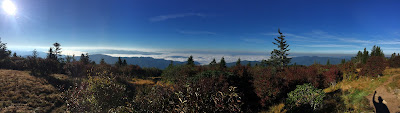
The hike starts at 8am, so the early rise was to try and catch sunrise from the Clingmans Dome Tower. After a mandatory stop at Bojangles, I made it to the parking lot around 6:30, ate breakfast and headed up to the tower on what has become one of my least favorite walks, the paved half mile Clingmans Dome Nature Trail. After a few minutes in the tower, I was joined by Randy just before the sunrise. Getting up so early and walking straight up that road doesn't sound like very much fun but the results are so worth it.


The sunrise at Clingmans Dome

Its hard not to feel the absolute presence of God when faced with such incredible beauty.


Amazing!

My favorite of the 89 pictures I took of the sunrise. 

After the sun took its place in the sky, Randy and I made our way back down the paved road and met up with the group. We're joined by some usual suspects (Eddie, Dawn and Cindy) and a bunch of new faces. I finally get to meet fellow hiker, facebook friend and blogger Amanda Lucy Haskins whose posts and blog I always enjoy. Instead of JD (who I think I may have referred to as the devil), this hike will be led by Tim. After a few introductions and a head count, we're off down the trail!


We're soon on Forney Ridge Trail. This is a heavily used trail and definitely has that touristy feel to it. Its a little rocky and has some steps here and there but is basically a pretty easy hike. I love the fact that Tim leads by following, it gives a lot of freedom to hike your own hike. After 1.1 miles we come to the first trail junction of the day as we reach the Forney Creek Trail. There was talk between me, Eddie and Randy about taking a little off-trail adventure here to find the Norwood Boiler off of Forney Creek but since we're with a large group and time is a factor (we have a bus to catch at 4pm) we decided it best to save that for another day. From here the trail begins a bit of an uphill climb before leveling out as it opens up into Andrews Bald. My last visit here was marred with dense fog. That would not be the case today!


Andrews Bald
After absorbing the incredible views from the bald, we head on down Forney Ridge. The trail instantly becomes overgrown and very narrow. Its no longer a tourist trail for sure. After a short while, Randy and I are separated from the masses and its just a moderate, sometimes steep, downhill journey through the woods.


Forney Ridge Trail

At 5.6 miles in, we reach the next trail junction with Springhouse Branch Trail. Springhouse goes left to the Nolan Creek Trail or right to Forney Creek Trail which is where we'll be heading after a quick snack. We also get to marvel the wonder that is Dawn Eipeldauer as she becomes the first victim of the trail. Nothing holds this woman back! Tough as nails!


Dawn laughing at her bloody leg! Bring it on!

Springhouse Branch begins with a bit of climbing to get a good sweat going. Although its a lovely walk through the woods, there's nothing particularly spectacular about this trail. A few people saw a mama bear and her cubs but I missed out on that. It was somewhere around here that Randy started having knee troubles. We were slowed a bit but he kept hiking through the pain. Like he had a choice, right? Soon we're stopped by another hiker, Todd, as we came upon a yellow jacket nest that he'd already been introduced to by way of a sting on his hand. Some went up and around, some of us more foolish just ran through the bees. Unfortunately, Randy seemed to further hurt his knee as he ran through and stopped abruptly. Ever since hurting my own knees, I carry knee braces in my pack at all times so I gave him one. It seemed to help somewhat. We hiked for a while with a new hiking buddy, Lori Kirk Mize. Good conversation helps pass those miles especially on these longer hikes.

Before long we reach the next junction with Forney Creek at campsite #71. Evidently, the campsite must have been an old CCC camp from the standing chimney and clearly defined rock pathways. Pretty cool.


Standing chimney at campsite #71

It was lunch time and Randy definitely needed a little time off that knee. We shared lunch we the gang. Good company as always!  :)


What a lovely and wonderful group of people!
Back row is Cindy and Dawn while the front row is Eddie, me and Randy.
 

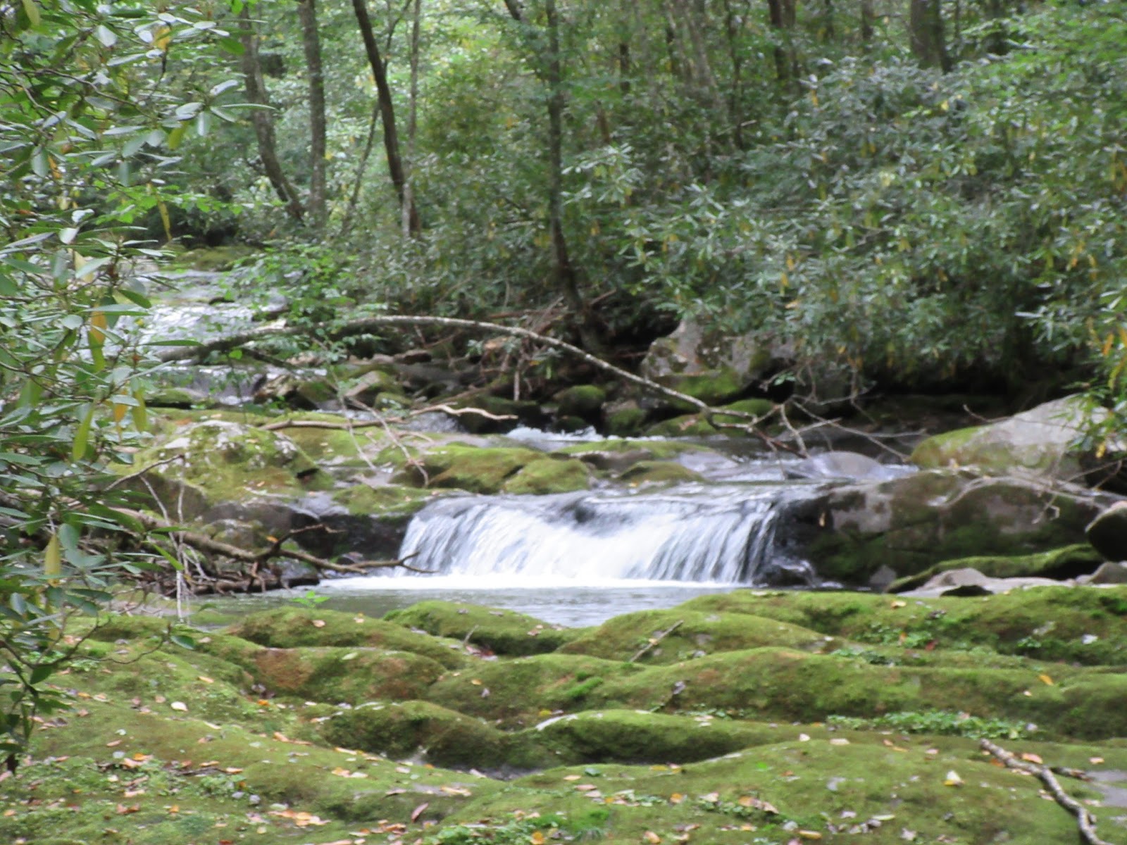
From here, we head down Forney Creek. Slowly. We pass an old homesite to the right where we see the ruins of a stone chimney and what looked like the remains of a car. Looks like this could be an interesting place to explore someday.


Old car?

I'm starting to worry about Randy and so is he. The trail runs along the creek and is probably the nicest part of the hike since we left Andrews Bald. Its mostly smooth and somewhat level which is good for Randy and he soon begins getting back in a groove as we reach the junction with Whiteoak Branch Trail.

Whiteoak ascends slowly for the next mile or so before descending into the Lakeshore Trail. I don't have any fond memories of Lakeshore. As a matter of fact, I dreaded it all day. Its still a bitch, but not nearly the killer it was a year ago. There's a heavy dose of trail maintenance going on here. Its been dug up and graded to the point of being unrecognizable. Not sure what that's all about but I didn't care for it all. Its more of a four wheeler road than a trail.

As we reach the junction with the Tunnel Bypass Trail, we decide "why not?" and add the extra mile. The Bypass is anticlimactic but at least its an actual trail and not some overly graded dirt road like Lakeshore. Soon we pass the junction with Goldmine Loop and make our way on out the next .4 of a mile to the road. Since Randy had never seen the tunnel, we walked up to and through it and back before the bus came.


The Tunnel to Nowhere (note the trash on top...)

At the end of the day, it was a good hike and a good time with the exception of Randy's knee scare. I'd say this is mostly a hike for mile markers since there's nothing particularly outstanding once you pass Andrews Bald. The area around campsite #71 is interesting but probably more assessable from the Lakeshore side. It was, as always, great hiking with old and new friends!


TRAIL REVIEW

Forney Ridge Trail - 5.6 miles

Springhouse Branch Trail - 4.2 miles

Forney Creek Trail - 1.3 miles

Whiteoak Branch Trail - 1.8 miles

Lakeshore Trail - 1.3 miles

Tunnel Bypass Trail - 1.6 miles

Campsite #71


Wanna join the Great Smokies Hiking and Adventure Club? Click here!

Wanna hike the 900 without getting lost? Start by checking out the book Day Hiker's Guide To All The Trails In The Smoky Mountains by Elizabeth L. Etnier.

Hiking Trails of the Smokies or "The Little Brown Book" from the GSMA


There is loads of information in the pages of GoSmokies.com.

Goshen Prong Trail

Hike #49 : September 13, 2015


16.8 miles
7.6 new miles
601.1 total overall miles
398.2 total miles of 800.8

For toady's hike: Eddie, Randy and I are headed to Goshen Prong Trail. Goshen Prong Trail is located off the Appalachian Trail 2.4 miles from the Clingmans Dome parking lot. So, a steep climb up the paved road, or take the bypass if you prefer, leads to the junction with the AT.

Things start out with a chilly 39° temperature and some strong winds. After all the heat of the summer... it feels amazing! The walk along the AT to get to Goshen is usually one filled with excellent views but today's heavy fog is blocking all that out. Still, its a pleasant, albeit wet, hike to the trail.


An early and foggy wet morning on the Appalachian Trail

As we reach the Goshen Prong Trailhead, we begin our decent down the mountain. Its a slick and rocky start reminiscent of the Road Prong Trail we hiked a while back. This soon becomes very clear to Randy as he almost fell. And, of course, moments after nearly falling, he totally wipes out! Being the helpful and supportive hiking buddy I am, I immediately pulled out my camera for this wonderful picture...


Randy Hullinger, ladies and gentlemen. Lol!

After Randy gained a little composure, we continued on. The trail continues downhill almost exclusively over rock, roots and smooth surfaces. Its an ever changing trail with wild diversity. At about 5.5 miles from Clingmans Dome, we reach a cave to our right directly on the trail. Its pretty small but Eddie was able to climb in for a look around.


Soon after passing the cave, the real adventure begins. There are numerous water features along the trail. Most of which are hard to see but with a little extra work and some slight off-trail meandering... the magic of these mountains starts to really show off.


Its hard to put into words how much fun it is discovering beauty like this on a trail when you had no idea it was there. We were like little kids climbing up and down banks, through thick rhododendron, rock hoping here and there and even attempting to shimmy across a fallen tree (Randy!)! Loads of fun!

As the trail begins to turn somewhat from the water, the trail becomes as flat as any I've been on. Easy hiking (and I rarely ever use the word easy!). As we enjoy this easy walk, we come to the popular "Goshen Gate Bridge" that crosses the Little River.


The steel Goshen Gate Bridge


From the bridge, the trail widens into a road bed for a few hundred yards before ending as we reached the Little River Trail junction. I absolutely loved every beautiful mile of  the 7.7 that make up the Goshen Prong Trail. I have a feeling most people miss this trail and even the ones who do hike it probably miss some of the best parts. From here we followed Little River Trail to Husky Gap Trail and followed that out to Newfound Gap Road rapping up a terrific 16.8 mile hike and a perfect day in the Smokies!


Previous blog about the Little River Trail and Husky Gap Trail can be found here.

Previous blog about the hike along the AT can be found here.


TRAIL REVIEW

Clingmans Dome Trail (paved) - .5 mile

AT from Clingmans Dome to Goshen Prong Trailhead - 1.9 miles

Goshen Prong Trail - 7.7 miles

Little River Trail - 1 mile

Husky Gap Trail - 4.1 miles


Campsite #23 and #21


Wanna hike the 900 without getting lost? Start by checking out the book Day Hiker's Guide To All The Trails In The Smoky Mountains by Elizabeth L. Etnier.

Hiking Trails of the Smokies or "The Little Brown Book" from the GSMA


There is loads of information in the pages of GoSmokies.com.